
Table of contents
What We Support
What We Oppose
Responsible urban development that does not worsen flooding
A clear, funded catchment-wide flood plan before major growth
A solution to flooding issues must be in place prior to any large-scale development in the catchment
We are extremely concerned about the adverse effect from stormwater runoff generated from an extra 2,020 dwellings and new roads.
Increased stormwater will flow into the Kaipara River, severely increasing flood risks across the whole catchment.
Essential infrastructure in place first: Planned, funded and timed properly
A development this big is not suitable for Waimauku and is irresponsible as it would quadruple the size of Waimauku, with no additional infrastructure.
Existing roads cannot handle another 4,000 cars (Public transport is inadequate).
It would have serious impacts on the wider Northwest area.
No public wastewater system exists or is planned in the next 20 years. The Wastewater from 2k dwellings poses a serious environmental risk. No feasible arrangements are evident in current plans.
Build where housing is already permitted:
Prioritise areas already zoned for urban development, housing and growth, rather than trying to rezone rural land.
Satellite Developments (Waimauku West):
Projects located far from the Auckland CBD (e.g., 35 km) that lack established urban infrastructure.
Integrated Corridor Use:
Use existing roads, rail lines and transport routes more efficiently, reducing the pressure on the wider region.
Corridor Overextension:
Forcing new developed upon over-stretched links into regional corridors that were not designed for high-density commuter loads.
Metropolitan Proximity:
Utilising land with close proximity to essential metropolitan services and transport hubs.
Loss of Productive Farmland:
Taking working farmland out of production and turning it into land that can sit idle for decades while owners wait for prices to rise.
Build where the basic infrastructure already exist:
Build where water, wastewater and roads are already in place.
Fast-tracking without infrastructure:
Approving developments without confirmed water, wastewater, roads, and other basics needed to actually function.
Solving the Housing Shortage:
Genuine delivery of homes to address supply issues.
Opportunistic Land Flipping:
Large-scale property sales to developers who may wait 50 years for the “economics to stack up.”
Compact Urban Growth:
Build in and around existing suburbs so we get better value from the pipes, roads and rail we have already paid for.
Skipping over good land, the “Leapfrog” effect:
Ignoring suitable land and jumping to remote sites which forces costly new water, wastewater, roads, and transport links.
Economic Feasibility:
Development based on math that actually “works” – ensuring the cost of building aligns with market reality.
Speculative Land Uplift:
Using fast-track processes primarily to increase land value for the landowner rather than for immediate building.
The bottom line
This proposal is being pushed through quickly, without the flooding and infrastructure risks being clearly addressed.
It will send more stormwater into the Kaipara River during storms, making the existing flooding problem for Waimauku and Kumeu worse.
Critical infrastructure to support a development of this scale is not confirmed or funded. This proposal is being processed under the Fast-track Approvals Act.
We do not think the Waimauku West development should be fast-tracked.
If you live, work, or own a business in the area, this proposal will affect you, regardless if your property is adjacent to the Kaipara River or not.
WHAT YOU CAN DO
- Share this information with your neighbours and friends.
- Attend local meetings to hear about what you can do to oppose the Waimauku West development.
- Become a member of the Waimauku Community Association to make sure local voices are heard
- If you are an affected neighbour, register this by emailing contact@fasttrack.govt.nz (and copy info@fasttrack.govt.nz).
Use the subject line: “Waimauku West (FTAA 2511-1134) affected party”.
Include your name, address, and how you are affected.
This needs to be done as soon as possible. - Contact your local elected representatives and ask them to oppose the proposal in its current form:
- Chris Bishop (Minister for Infrastructure) – chris.bishop@parliament.govt.nz
- Chris Penk (National MP) – chris.penkMP@parliament.govt.nz
- Tracey-Lee Repia (Labour Candidate)
- Zephyr Brown (Greens Candidate) – zephyr.brown@greens.org.nz
- Greg Sayers (Rodney Ward Councillor) – greg.sayers@aucklandcouncil.govt.nz
- Guy Wishart (Chairperson, Rodney Local Board) – guy.wishart@aucklandcouncil.govt.nz
WHY THIS MATTERS
Fast-track this now and the community wears the flood risk, the infrastructure costs, and the long-term damage, with little say in a decision that will shape our future.
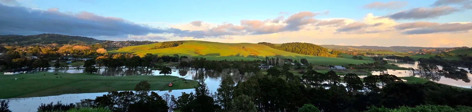
Project location
The project area is approximately 196 hectares of rural land at 1080 State Highway 16, Waimauku, Auckland region, located south of the North Auckland Railway Line.
Project summary
The project involves:
- a residential development comprising approximately 1,500–2,020 dwellings at a range of densities
- a neighbourhood centre
- a light industrial area
- two indicative school sites
- a green network that integrates existing ecological features, stormwater management, and public open spaces
- supporting infrastructure, including:
- private stormwater systems
- a private water supply solution
- two wastewater disposal options: connection to the public network connection, or onsite treatment and disposal.
Key data and Timeline
On 24 February 2025 Auckland Council was gazetting the acquisition of 1080 State Highway 16 (Pukeatua Block – the subject site) under the Public Works Act for cemetery purposes. The notice of intention was published on the Gazette website.
On 20 March 2025 Federated Farmers objected to the acquisition, stating concerns about the loss of productive farmland. Ref: https://www.fedfarm.org.nz/Web/Web/Policy/Submission/2025/March/Letter-of-objection-to-the-Compulsory-Acquisition-for-Cemeter-20-Mar-2025.aspx
Auckland Federated Farmers has concerns around the loss of productive farmland, which stems from the current trend of some farmland diversifying into non-food production industries such as carbon farming and renewable electricity. We acknowledge that non-food production industries have multiple benefits, but at the end of the day do not provide food essential for human well-being.
We are aware that the property is at least partly located on land classified as LUC 1-3 land, meaning it is classified as ‘highly productive land’ (HPL) under the National Policy Statement for Highly Productive Land (NPS-HPL). This means that the land is subject to associated restrictions and limitations on its development.
Federated Farmers, 20 March 2025, addressed to the Registrar, Environment Court.
It would appear that Federated Farmers were only concerned about the loss of highly productive land for cemetery purposes, not for housing purposes.
On 14 July 2025 Auckland Council publishes a memorandum not to proceed with Public Works Act acquisition of 1080 State Highway 16 for cemetery purposes, stating as reasons:
- An inability to address concerns raised by mana whenua, which could not be resolved through engagement, and would likely delay or prevent the ability to obtain the necessary Resource Management Act 1991 (RMA) zoning/consents to enable the land to be used as a cemetery.
- Further information becoming available of a proposed alternative use of the land for housing, due to the council being advised of a Fast-track Approvals Act 2024 application being progressed, which is supported by mana whenua.
The council also noted that it “was also recently made aware of a proposed application by HHL under the Fast-track Approvals Act 2024 for residential dwellings on the site, and that mana whenua were in support of the application.”
14 July 2025 Auckland Council
1st July 2025, councillor Greg Sayers did publish a post on his website that also addresses flooding but fails to highlight the actual issue. “Auckland Council needs to stop granting consents for houses in flood plains, particularly when this puts lives at risk.”.
While we obviously agree with that sentiment, it should be noted that this is not the only issue.
With more development outside the flood plains, the increased stormwater from those developments will broaden the existing flood plain and thus the harm to people that were never part of this.
He also states that “Keeping the roadside drains open and clear of blockages is equally important”. While this is important for the people living around those drains, the increased capacity and more importantly velocity will worsen the flooding and backflow downstream, again affecting people that were never part of any flood plain.
This is exactly what WCA is mostly concerned about as it is an unregarded issue, particularly for the Kaipara catchment due to its tidal character.
Auckland’s new cemetery dead and buried
Newsroom article from 23 July 2025.
Late July 2025 members of the WCA have been writing emails to Kaipara Moana, Whititera Trust, Rodney Local Board, local MP Chris Penk and Chris Bishop, stating concerns about flood risks relating to the proposed housing development.
Only very few responses were received, mostly auto replies.
Fast Track Application
On 24 November 2025 the application for fast track referral was lodged.
The briefing to the minister reads:
6. The applicant indicates that the project may involve earthworks in or near natural inland wetlands, potentially triggering a prohibited activity under Regulation 53 of the National Environmental Standards for Freshwater (NES-F). The applicant states the current masterplan is high-level and intended to support the referral application, with detailed design and confirmation of the prohibited activity to follow if the project proceeds to a substantive application.
7. Under Regulation 53(1) of the NES-F, earthworks within a natural inland wetland are classified as a prohibited activity if they result, or are likely to result, in the complete or partial drainage of the wetland, and they do not have another activity status under Regulations 38 to 51 of the NES-F.
8. If you agree to progress the project to our Stage 2 analysis, the next briefing will require you to consider whether to decline the referral application on the basis that it may involve a prohibited activity. This is a potential reason you may decline a referral application under section 21 (5) of the Act. However, we note section 21 (7) of the Act explicitly states that the presence of a prohibited activity does not, in itself, prevent you from accepting a referral application.
Fast-track website: Stage 1 briefing to Minister
Weirdly enough, the same briefing to the minister states that the applicant notes:
The applicant notes that the site offers an alterative to other future urban areas in Kumeu—Huapai and Riverhead, where development capacity has been reduced due to flooding and natural hazard risks. The applicant states the project includes a neighbourhood centre, light industrial area, and a green network, supporting residents’ wellbeing and access to employment, recreation, and services. The applicant states the site is currently served by a 30-minute frequency bus route connecting to Westgate and promotes active transport options.
Fast-track website: Stage 1 briefing to Minister
The Minister for Infrastructure referred the project to the Fast-track on 2 March 2026.
The reasons why the applicant chose the fast-track option instead the normal resource consent application, is noted prominently in the minister’s decision to accept to application for referral:
referring the project to the fast-track approvals process would facilitate the project, including by enabling it to be processed in a more timely and cost-effective way than under normal processes [s22(1)(b)(i)] because:
i. the project may involve a prohibited activity under the National Environmental Standards for Freshwater, which would preclude it from progressing through the standard RMA consenting pathway – prohibited activities may be considered through the fast-track approvals process
ii. appeals under the Act are only to the High Court rather than the Environment Court and are limited to points of law
iii. the Act precludes public and limited notification.
Fast-track website: Notice of decision
Detailed Points of Contention with Waimauku West
Stormwater Volumes Increase Flood Impacts
Waimauku West maintains their development is “flood neutral” meaning any event larger than a 10-year rain fall with an Annual Exceedance Probability (AEP) of 1% will flow directly to the river which will already be in flood. The Resource Management Act (RMA) allows that scenario to occur.
AEP of 1% means that the flood volumes are modelled on a ten-year rainfall event happening 1% of the year, so the consent would be granted on the basis that 3.65 days a year the catchment can experience a 1 in 10 year rainfall event where all stormwater will bypass storage devices within the development and flow unfiltered and unrestrained directly to the Kaipara River.
1 in 100-year events are modelled the same way – it is acceptable under the RMA for the catchment to receive a 100-year rainfall event straight of the development to the river 3.65 days a year.
The development will turn 196 hectares of farmland into something like 80% impermeable surface, all that rain that would have soaked into the ground will now flow to the river.
Waimauku West should contain a 1 in 100-year event on their own land (they have an additional 800 hectares outside the proposed development they could utilise). The stormwater volume would be stored and its passage to the river delayed so it won’t add to the flooding.
To enable that approach, Council first need to produce an Integrated Catchment Management Plan (ICMP) and flood model as part of a wider flood prevention strategy before any further intensification happens within the catchment.
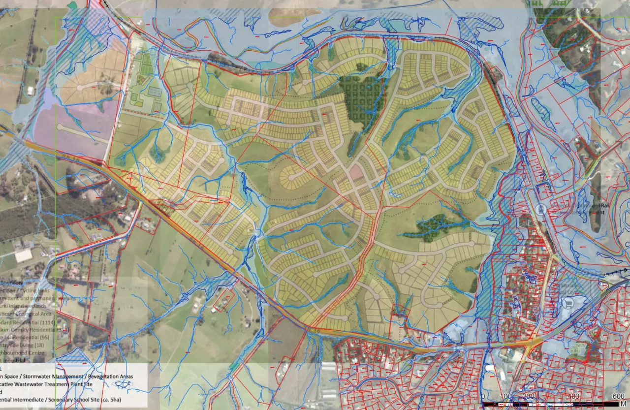
Montage of proposed Waimauku West development over the Auckland Council GIS Floodplain information
Economic Benefits
The Fast-Track Act refers to the provision of much-needed housing.
The Council Economist was unconvinced of the benefits claimed by Waimauku West and the substantive application is required to expand on these claimed benefits.
Data from ANZ shows that there is no current short term nor medium term need for the housing proposed under the application. There are already seizable portions of undeveloped urban zoned land in Auckland. There is no need to convert highly productive farmland into urban lots.
When you look at the graphs below and analyse the demand supply curve over the past quarter-century the reality is that we seldom have a real shortage of dwellings and the abrupt spikes are short term and over reported in the media whilst being weaponised by politicians.
Fundamentally the supply and demand paradigm is a false narrative.
The data below is from a 2026 ANZ bank report on housing supply and demand
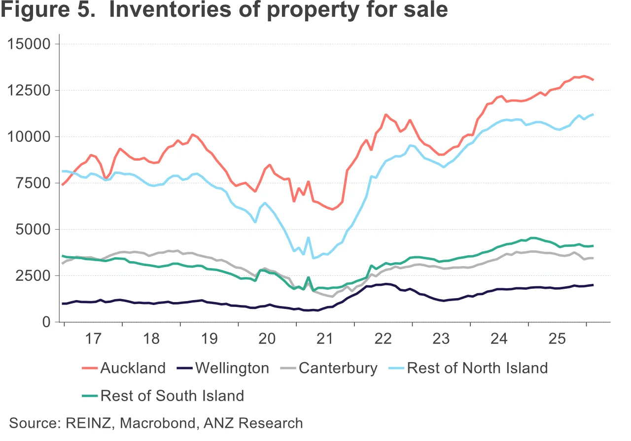
The steady pipeline of new listings is showing up in inventories for sale, which continue to sit at high levels overall and are still rising in the North Island outside of Auckland and Wellington (figure 5).
Retrieved 13 April 2026 from https://www.anz.co.nz/about-us/economic-markets-research/property-focus/
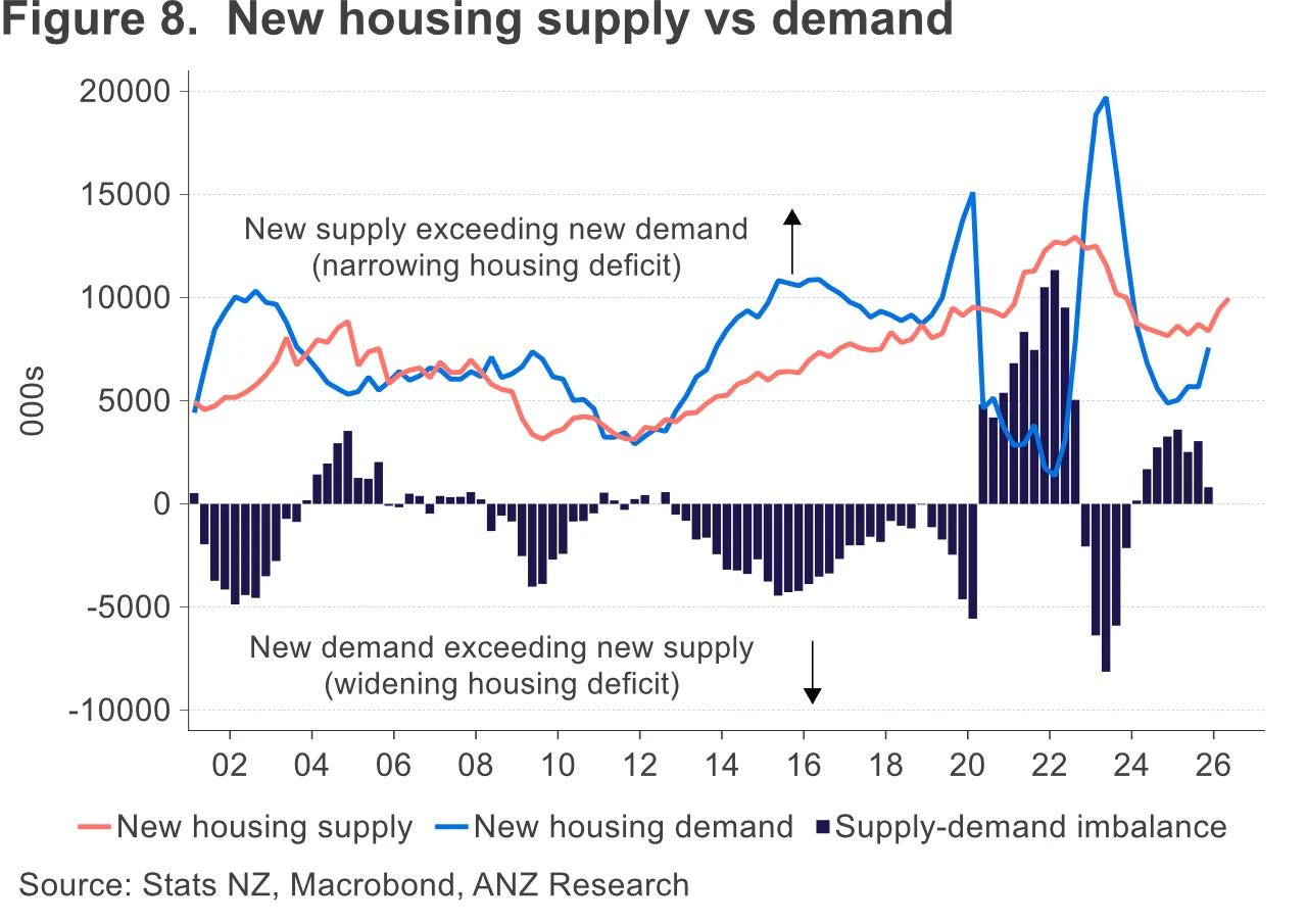
Although building work put in place was weaker than expected in the 2025 Q4 GDP data, that’s probably timing. The pickup in consents – from what was actually a historically fairly solid level at the housebuilding trough – is helping to keep the market well supplied (figure 8).
Retrieved 13 April 2026 from https://www.anz.co.nz/about-us/economic-markets-research/property-focus/
Infrastructure
Waimauku West is a development isolated from all the infrastructure needed to support it, those elements are not part of the application, there is no plan for them and therefore no funding – roading, public transport, waste water, drinking water, flooding and stormwater are all concerns echoed in the written comments received from the consultation for referral.
The development would more than double the population of Waimauku with none of the roading and transport infrastructure to support the increase in vehicle movements.
Bus and train services
Bus services from Waimauku to Westgate are only every 30 minutes during weekdays from 5.30am to 8.30am, and again from 4.30pm to 8pm.
From Westgate to Waimauku is half-hourly 7-8am, and 3pm to 8.30pm.
Outside those times the service runs hourly.
Weekend services are less often.
Train services are non-existent from Waimauku.
The closest train station is Swanson, approx. 25 minute drive away.
The bypass
The transport report of the Fast-Track application mentions that the development of the by-pass starts in 2028. That is not correct.
It is the work around the intersection of Coastesville-Riverhead Highway and SH16 that is planned for around then at this stage. That is quite different to the by-pass development.
Indicative School Sites
There is no certainty around the proposed school sites, a new high school has already been designated in Huapai, a process that took well over 25 years to be actioned.
Those school sites look good on paper, but they are a false promise.
The fact is – Ministry of Education have no new schools planned within the development.
Does Waimauku West Provide Climate Change Mitigation?
No, it does the opposite. Waimauku West will accelerate climate change effects by increasing flood volumes, eroding habitat for endangered species and pumping insecticide and fertiliser residue into the river and harbour.
The response from the parties invited to comment on the referral application states that the development will exacerbate existing environmental issues, in particular flooding.
Significant Ecological Areas (SEAs)
Waimauku West contains and is surrounded by SEAs, yet the applicant has only carried out “desktop” reviews and site visits. No site-based investigations that produce real life data, so no real understanding of cause and effect.
The development will obliterate native bat habitat and natural wetlands.
As affected parties we need to contribute to the ecological management plan for the SEAs.
Loss of Productive Land
When Auckland Council sought to acquire the land for a new cemetery in 2025, The Landowner stated to One News that the cemetery would take their best productive land where they made all their silage, they called the council plan ill-considered and said they did not think a cemetery would be an appropriate visual gateway to Waimauku or Helensville.
When council abandoned the cemetery acquisition it appeared to be a victory for the landowner, iwi and the wider community – that the land would remain as productive whenua.
However, The Landowner was already underway with their submission for fast-track referral – to turn that same highly productive land and visual amenity into more than 2,000 homes.
The Landowner should be honouring their 2025 publicly stated intention to retain the land as a productive whenua, showing some integrity and respecting the support the community provided when they sought to repel the council cemetery plan.